ISSUED 16:30EST 09/25/2024
VALID UNTIL 20:00EST 09/25/2024
NEXT UPDATE: 19:30EST 09/25/2024
FORECASTER: Timothy Hayes Torcon WX Team Torcon Weather Team Southeast Region
Hurricane Helene is currently located in the Gulf of Mexico, moving north-northwest towards the Florida Panhandle.
As of Wednesday, September 25, 2024, the storm has intensified into a hurricane with sustained winds of 80 mph. It is expected to make landfall in the Big Bend region of Florida on Thursday evening.
Category (1) Hurricane
Central Pressure is 978MB
Max Winds 87MPH
Moving North at 10MPH
We are anticipating Helene to make a North/Northeast turn today and will see an increase in speed. Helene is forecast to make landfall inside the Big Bend area of the FL Panhandle. Once Helene makes landfall we will see a drastic slowdown of the system. After landfall Helen will make a Northwest turn across the Southeast US. We will see Helene stregthen as she approaches the Big Bend Area of FL. Helene’s initial fast forward momentum will cause Hurricane and Tropical Storm Force winds to be felt well inland as far north as Northeast GA and the Southern Appalachian region. School districts have already begun to cancel school for Thursday in anticipation of Tropical storm conditions.
Due to the sheer size of Helene Hurricane-force winds extend outward up to 25 miles (35 km) from
the center and tropical-storm-force winds extend outward up to 275
miles (445 km).
***********************************************************************
The following information is from the National Hurricane Center.
***********************************************************************
HAZARDS AFFECTING LAND
———————-
Key Messages for Helene can be found in the Tropical Cyclone
Discussion under AWIPS header MIATCDAT4 and WMO header WTNT44 KNHC
and on the web at hurricanes.gov/text/MIATCDAT4.shtml
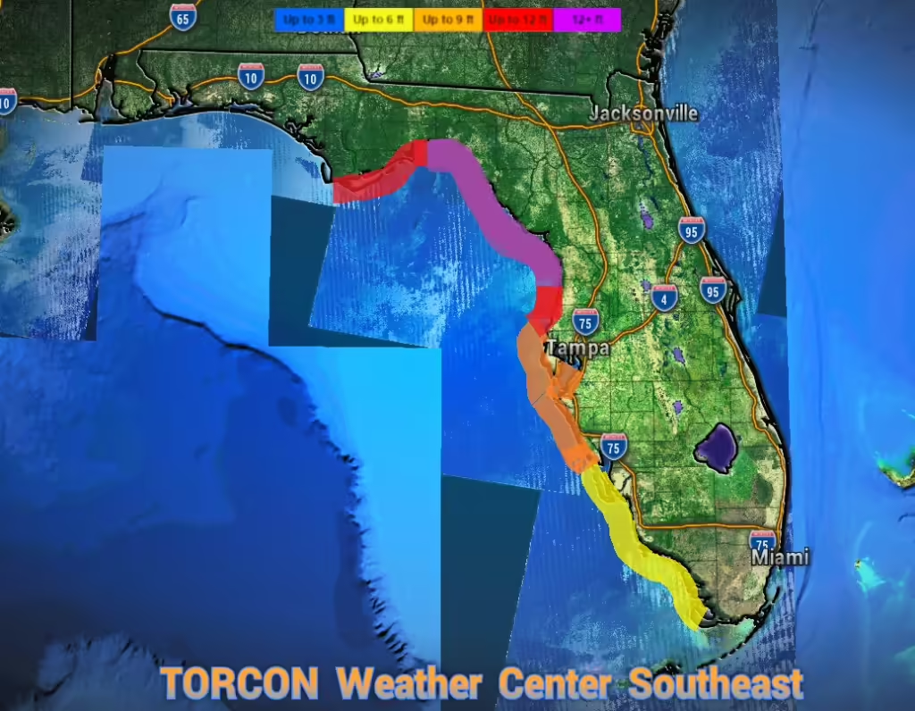
STORM SURGE: The combination of a life-threatening storm surge and
the tide will cause normally dry areas near the coast to be flooded
by rising waters moving inland from the shoreline. The water could
reach the following heights above ground somewhere in the indicated
areas if the peak surge occurs at the time of high tide…
Carrabelle, FL to Chassahowitzka, FL…12-18 ft
Apalachicola, FL to Carrabelle, FL…8-12 ft
Chassahowitzka, FL to Anclote River, FL…8-12 ft
Indian Pass, FL to Apalachicola, FL…6-9 ft
Anclote River, FL to Middle of Longboat Key, FL…5-8 ft
Tampa Bay…5-8 ft
Middle of Longboat Key, FL to Englewood, FL…4-7 ft
Englewood, FL to Flamingo, FL…3-5 ft
Charlotte Harbor…3-5 ft
For a complete depiction of areas at risk of storm surge inundation,
please see the National Weather Service Peak Storm Surge Graphic,
available at hurricanes.gov/graphics_at4.shtml?peakSurge.
Storm surge could raise water levels by as much as 2 to 4 feet above
normal tide levels in areas of onshore winds along the southern
coast of Pinar del Rio, Cuba, including the Isle of Youth.
Storm surge could raise water levels by as much as 3 to 5 feet above
ground level in areas of onshore winds within the warning area along
the north coast of the Yucatan Peninsula.
WIND: Hurricane conditions are expected within the U.S. hurricane
warning area late Thursday, with tropical storm conditions
beginning Thursday morning. Tropical storm conditions are
expected in southern Florida later today and will spread northward
across the rest of Florida, Georgia, and South Carolina through
Thursday. Tropical storm conditions are possible within the
tropical storm watch area in South Carolina beginning on Thursday.
Hurricane conditions, especially in gusts, are expected in the
hurricane warning area in Mexico during the next several hours.
Tropical storm conditions are occurring in the warning area in Cuba,
and hurricane conditions are possible for the western portion of
Cuba today.
RAINFALL: Helene is expected to produce total rain accumulations of
4 to 8 inches over western Cuba, the Cayman Islands, and the
northeast Yucatan Peninsula, with isolated totals around 12 inches.
This rainfall brings a risk of considerable flooding. A 24-hour
rainfall total of 8.60 inches (218.4 mm) was recently reported in
Embalse Herradura, Pinar del Rio, Cuba, by the Meteorological
Service of Cuba.
Over the Southeastern U.S. into the Southern Appalachians, Helene
is expected to produce total rain accumulations of 5 to 10 inches
with isolated totals around 15 inches. This rainfall will likely
result in areas of considerable flash and urban flooding, with areas
of significant river flooding. Landslides are possible in areas of
steep terrain in the southern Appalachians.
TORNADOES: A tornado or two may occur tonight over parts of the
Florida Peninsula and southern Alabama. The risk of tornadoes will
increase on Thursday, expanding northward across Florida into parts
of Georgia and South Carolina.
SURF: Swells generated by Helene will affect the southern coast of
Cuba and the Yucatan Peninsula of Mexico during the next couple of
days. Swells will spread northward toward the west coast of Florida
and the northeastern Gulf Coast later today and Thursday. These
swells are likely to cause life-threatening surf and rip current
conditions. Please consult products from your local weather office.
It is important for everyone across the Southeast Especially in FL and GA to pay close attention to information being put out by your local officials, The National Weather Service and Local Weather News. You can count on the TORCON Weather team to keep you updated with any severe weather Alerts and News for the duration of the storm. THE TORCON Hurricane Center Will Move to Condition Orange at 18:00EST and Condition RED Several Hours before Landfall. We have all hands on deck and our weather professionals from across the country are monitoring this storm. We have chase teams in route to intercept Helene and we will broadcast their feed LIVE. Make sure you have your Emergency Kits ready. Make sure you have plenty of medication to last you for at least a Week. We are anticipating power outages across the Southeast that may last for Days. Now is the time to make your final preparations. Remember to brining your pets. Once landfall is imminent Conditions will deteriorate across the Southeast Rapidly. Stay indoors and only travel if it is an emergency. WE have an Extreme FLOOD RISK with this system. DO NOT DRIVE ACROSS FLOODED ROADWAYS! People driving in flood waters and across Flooded roads is the Number one Killer during severe weather!

TORCON Weather/Hurricane Center Hurricane ADVISORY-0004ISSUED 16:30EST 09/25/2024VALID UNTIL 20:00EST 09/25/2024NEXT UPDATE: 19:30EST 09/25/2024
Hurricane Helene is currently located in the Gulf of Mexico, moving north-northwest towards the Florida Panhandle.
As of Wednesday, September 25, 2024, the storm has intensified into a hurricane with sustained winds of 80 mph. It is expected to make landfall in the Big Bend region of Florida on Thursday evening.
